Database Type: Geospatial
Connector Supports: READ only
Introduction
ArcGIS Online is an integrated server-based GIS that comes with end-user applications and services for spatial data management, visualization, and spatial analysis. It compiles geographical information in a database and displays it in the form of interactive maps that are published as web layers through a range of applications.
Being a SaaS, ArcGIS Online is hosted and managed by Esri and leverages its cloud infrastructure for geospatial data management along with making the information readily available to a wider audience through scalable web technology. It helps the users to upload and style geographic data, create web maps, interact with maps on any device and embed maps into websites and web-based applications.
ArcGIS Geodatabase supports multi-user relational database management system. It is a collection of geographic datasets of various types held in a common file system folder.
The geodatabase administrator can set the permission levels for the users to define their data access rights based on the four roles: None, Read Only, Read/Write, and Admin. VOGO Voice platform restricts the permission level to ‘Read Only’ where the user can only read the data provided and not perform the task of editing through the instance of an ArcGIS connector that has been created.
Anatomy of Settings
Defining Settings values for adding an ArcGIS Account
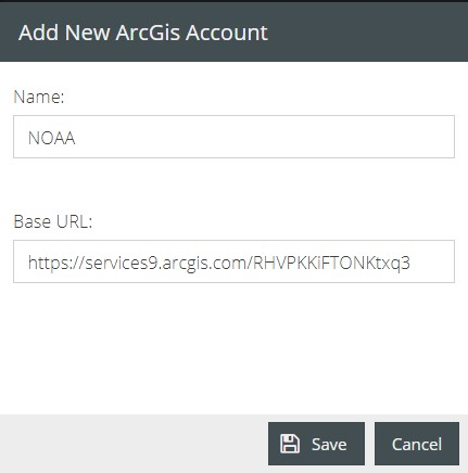
Name: It refers to the name assigned to the instance of the connector created.
Base URL: The resources and operations hosted by ArcGIS Services portion of REST API are accessible through the URL endpoint of the desired GIS service published with ArcGIS Server. The begging part of the URL before the ‘/arcgis/rest’ will allow the instance of the connector to be used for all feature servers hosted by the ArcGIS REST Service for a specific database. Each of these servers will contain one or more Feature layers that can be used within an interaction.
👍 Note: Many types of layers and services are provided by ArcGIS Server out of which the VOGO Voice platform supports only Feature Services and Feature Layers of open data.
How to locate the URL of a geodatabase
The open data portal of ArcGIS hub enables you to collaborate and share public content like web maps, story maps, data and more around a project or goal with people through initiatives.
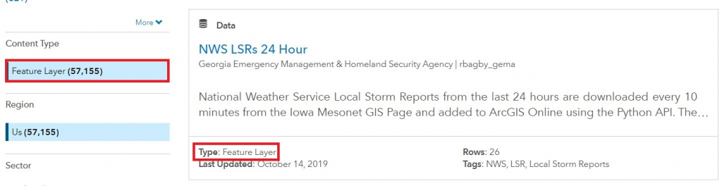
- Access ArcGIS hub http://hub.arcgis.com/ and navigate to ‘Data’ section from Search Hub content drop-down list.
- Select Feature Layer from ‘Content-Type’ and click on any of the desired datasets from the list of data displayed. Ensure that the selected dataset falls under the ‘Feature Layer’ type.
- You will be directed to the Dataset Preview page of the desired geo data service where the API button can be located on the right-hand side of the page. Click on the button and from the drop-down list copy the link for GeoService.
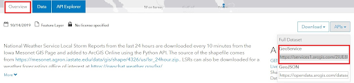
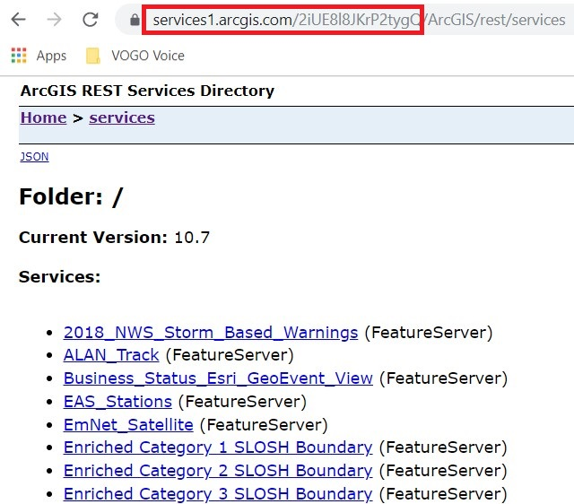
This is a URL endpoint that will direct the users to the ArcGIS Rest Services Directory of that specific ArcGIS Server site which provides a way for you to browse the list of all the feature services, folders, and operations on the server.
- To be pasted as base URL copy the part of the URL before ‘/ArcGIS/rest…’ which will connect the complete set of Feature Services with the instance of the connector to be used in the interaction flow.
Connector Usage
Now that a connector is established it can now be used within any interaction flow. Each usage of the connector will allow different configurations to retrieve different results. Those settings can be either static or dynamic based on the needs.
Anatomy of Configuration
Defining Configuration Values for an ArcGIS connector
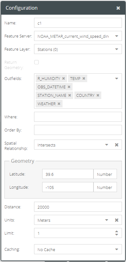
Name: The name assigned to identify the connector and the results data. The assigned name is used every time the connector is called to action through the components in the interaction builder platform.
Feature Server: It refers to a published service hosted by ArcGIS Rest Service. A feature server can contain datasets with or without a spatial column. Datasets with a spatial column are called layers and those without a spatial column are addressed as tables. A single geodatabase URL endpoint can hold many feature servers.
Pasting the URL endpoint will attach the complete folder of associated feature servers to the instance of the connector created. Click on the drop-down list of the Feature Server and choose the desired server from which the geospatial data has to be retrieved.
Feature layer: A feature layer is a dataset that can be used to display features from a single layer in either a Map Service or Feature Service. The features can be points, lines or polygons (areas).
Each feature server can contain one or more feature layers which can be a spatial layer or non-spatial table. Therefore the dropdown list of Feature Layer gets populated depending on the Feature Server selected. Click on the drop-down list and choose the desired Feature Layer from which geospatial data needs to be accessed.
Return Geometry: When Feature Layer is of type ‘Points’ the ‘Return Geometry’ will be available to be provided in the response. At present, the formats like polygons and lines are not supported for returning geometry.
Outfields: Outfields refer to the list of fields or attributes to be included in the returned resultset. When a Feature Layer is selected the outfields will be available to choose from the drop-down list. If there are no outfields specified then it returns data from all the fields of the selected Layer.
💡 Tip: It’s recommended to only return the fields that you need to use in your interaction flow.
Where: Where clause syntax helps to filter data based on non-spatial criteria. For example, in the WHERE clause for query filter WHERE City_Name = ‘Barrington’, it would filter and return all the attributes of that record in which the value of the field ‘City_Name’ is ‘Barrington’
To learn more about how to use WHERE clause for querying data visit https://developers.arcgis.com/rest/services-reference/query-feature-service-layer-.htm
Order by: It enables sorting thereby returning the result set of records in ascending or descending order based on the inputs of one or more fields selected. Use ASC or DESC for ascending or descending respectively, following every field to control the sorting. 🖍 Note: By default, it sorts in ASC (ascending order) if <ORDER> not specified.
Spatial Relationship: The spatial relationship is applied to input geometry while performing the query. Click the drop-down list and select the required type of spatial relationship to find features that spatially relate to each other in a map display.
To learn about the spatial relationship types visit https://desktop.arcgis.com/en/arcmap/latest/extensions/data-reviewer/types-of-spatial-relationships-that-can-be-validated.htm
Limit: After defining the metadata filters to query data, we can set the limit to select the maximum number of data records that have to be retrieved and displayed through the device from the filtered content. If Limit is set to 1, the feature layer will return only 1 data record even if the query matches multiple records.
Caching: To know about caching, click here.